
Air Navigation Mapping: World/Sectional Aeronautical Charts, Enroute Charts
Aperigae is the unique private company in Turkey to provice geo-support for IFR and VFR mapping.


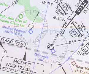
Aperigae is the unique private company in Turkey to provice geo-support for IFR and VFR mapping. Apetigae provides provides service, product and consultancy for geospatial data and mapping to support Visual Flight Rules (VFR) flights and Instrument Flight Rules (IFR) flights. Aperigae’s service for IFR comprises both Enroute Low Altitude Charts and Enroute High Altitude Charts. Regarding the VFR flights, Aperigae provides service for World Aeronautical Charts at scale 1:1M, Sectional Aeronautical Charts at scale 1:500K and Helicopter Route Chats.
The data compilation and integration for navigational content is perfomed by means of close cooperation with the customer in case of non-complete data and coverage. The topographic data content for VFR charts comprise populated places, drainage networks, transportation (roads, railroads), and other distinctive landmarks. The aeronautical information content of VFR charts comprise visual and radio aids to navigation, airports, controlled airspace, restricted areas, obstructions, and related data. Due to the scale, data is generalized for World Aeronautical Charts.
© Copyright 2025 Aperigae.com